k Antarctic peninsula landscape, satellite image Satellite image of the Antarctic peninsula landscape. It resembles a 1000kilometrelong arm covered with ice, stretching towards the southern tip of South America. The west coast of the peninsula has over 100 large glaciers and numerous islands, and moving northwards, there are many more islands separated from the peninsulas northwestern tip by the Bransfield Strait. To the east, you can see the A23a iceberg top, centreleft, which is currently the largest iceberg in the world. It calved from the FilchnerRonne ice shelf in West Antarctica in 1986, but only recently, driven by winds and currents, started drifting quickly away from Antarctic waters. In recent decades, the Antarctic Peninsula has experienced warming, and using satellites to monitor this region over this time period provides evidence of trends and allows scientists to make predictions about the continents future. Image data obtained by the Copernicus Sentinel1 satellite., by EUROPEAN SPACE AGENCYSCIENCE PHOTO LIBRARY Stock Photo - Afloimages
Sign up
Login
All images
Antarctic peninsula landscape, satellite image Satellite image of the Antarctic peninsula landscape. It resembles a 1000 kilometre long arm covered with ice, stretching towards the southern tip of South America. The west coast of the peninsula has over 100 large glaciers and numerous islands, and moving northwards, there are many more islands separated from the peninsula s northwestern tip by the Bransfield Strait. To the east, you can see the A23a iceberg  top, centre left , which is currently the largest iceberg in the world. It calved from the Filchner Ronne ice shelf in West Antarctica in 1986, but only recently, driven by winds and currents, started drifting quickly away from Antarctic waters. In recent decades, the Antarctic Peninsula has experienced warming, and using satellites to monitor this region over this time period provides evidence of trends and allows scientists to make predictions about the continent s future. Image data obtained by the Copernicus Sentinel 1 satellite., by EUROPEAN SPACE AGENCY SCIENCE PHOTO LIBRARY
RM

Antarctic peninsula landscape, satellite image

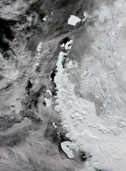
Satellite image of the Antarctic peninsula landscape. It resembles a 1000-kilometre-long arm covered with ice, stretching towards the southern tip of South America. The west coast of the peninsula has over 100 large glaciers and numerous islands, and moving northwards, there are many more islands separated from the peninsula's northwestern tip by the Bransfield Strait. To the east, you can see the A23a iceberg (top, centre-left), which is currently the largest iceberg in the world. It calved from the Filchner-Ronne ice shelf in West Antarctica in 1986, but only recently, driven by winds and currents, started drifting quickly away from Antarctic waters. In recent decades, the Antarctic Peninsula has experienced warming, and using satellites to monitor this region over this time period provides evidence of trends and allows scientists to make predictions about the continent's future. Image data obtained by the Copernicus Sentinel-1 satellite., by EUROPEAN SPACE AGENCY/SCIENCE PHOTO LIBRARY

Details

ID
245537684

Collection

License type
Rights Managed

Photographer


Sign in
Member access
Login not found.