k ERS2 satellite in Earth orbit, illustration Illustration of the European Remote Sensing satellite ERS2 in Earth orbit. ERS2 was launched on 21st April 1995. It contained instruments to measure ozone levels, sea surface temperatures and both wind speed and direction. It also had a radar altimeter. After 16 years of successful operation the satellite was retired in 2011 and began its deorbiting procedure. The satellite entered Earths atmosphere in February 2024, burning up on reentry., by EUROPEAN SPACE AGENCYSCIENCE PHOTO LIBRARY Stock Photo - Afloimages
Sign up
Login
All images
ERS 2 satellite in Earth orbit, illustration Illustration of the European Remote Sensing satellite  ERS 2  in Earth orbit. ERS 2 was launched on 21st April 1995. It contained instruments to measure ozone levels, sea surface temperatures and both wind speed and direction. It also had a radar altimeter. After 16 years of successful operation the satellite was retired in 2011 and began its deorbiting procedure. The satellite entered Earth s atmosphere in February 2024, burning up on re entry., by EUROPEAN SPACE AGENCY SCIENCE PHOTO LIBRARY
RM

ERS-2 satellite in Earth orbit, illustration

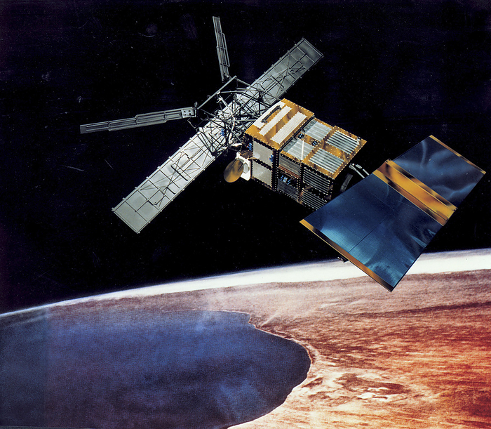
Illustration of the European Remote Sensing satellite (ERS-2) in Earth orbit. ERS-2 was launched on 21st April 1995. It contained instruments to measure ozone levels, sea surface temperatures and both wind speed and direction. It also had a radar altimeter. After 16 years of successful operation the satellite was retired in 2011 and began its deorbiting procedure. The satellite entered Earth's atmosphere in February 2024, burning up on re-entry., by EUROPEAN SPACE AGENCY/SCIENCE PHOTO LIBRARY

Details

ID
247588027

Collection

License type
Rights Managed

Photographer


Sign in
Member access
Login not found.